Disabling GPS on Android. Glonass. Is it possible to get rid of tracking? "Shock therapy" for the transport control system
Almost everything modern smartphones equipped with a GPS chip. The navigation module is present in most tablet computers operating under the control operating system Android. However, not all users know that the chip is often disabled by default. As a result, such people are surprised that there are no geotags on the photos, and the Google Now service does not show the route to their home. Fortunately, you can enable GPS on your tablet and smartphone without any effort.
Why do you need GPS?
Decades ago, GPS satellites were only available to the military. But the Americans quickly realized that big money could be made from navigation chips, applications and maps. As a result, ordinary people gained access to the technology - they just needed to acquire the appropriate device. Initially, these were specialized GPS navigators. And now the navigation module has seriously decreased in size, and therefore it can be built even into an ordinary smartphone.
A GPS signal helps you understand where in the world you are now. This is useful for several reasons:
- The navigation app will help you not get lost in the forest;
- With navigation you can navigate even in an unfamiliar city;
- You can easily find the address you need;
- You escape from traffic jams - the “Traffic” service helps you avoid them;
- Various apps show you nearby eateries and shopping centers;
- GPS helps determine your speed.
In short, a navigation chip can be very useful. But you will have to pay for using it. If you decide to turn on GPS on Android, then get ready for higher power consumption. This is most noticeable on older devices that do not support A-GPS technology. Also, inexpensive ones have a problem with GPS signal reception. Ours will help you get closer to solving it.
GPS activation
But enough of the lyrics... Let's find out how to turn on GPS on your phone under Android control. This is done very simply:
Step 1. Go to the device menu and tap on the “ Settings».
Step 2. Here select " Location».

Step 3. Click on the item " Mode».

Step 4. Select location mode " According to all sources" or " By GPS satellites ».

On smartphones running more current versions of Android, GPS can be enabled through the notification panel. To do this, just activate the button "GPS"(depending on the manufacturer, it may have a different name). By long pressing on this item you can go to the location settings and change other parameters. For example, enable energy saving mode or high accuracy.

Please note: On smartphones and some other devices, the item names may differ. For example, the section " Location" may have the name " Geodata».

All modern Android smartphones and tablets are equipped with a GPS module. This allows these devices to be used as GPS navigators. In addition, the presence of a GPS module allows you to leave GPS tags on photos and use many other useful functions. In this regard, many novice users are interested in how to enable GPS on Android. In this article we will briefly consider this issue.
As a rule, Android devices have a GPS module enabled. But, if you previously disabled this function, and now you want to turn it back on, then you need to open Settings and go to the “Location” section.
At the top of the “Location” section there is a switch that is responsible for disabling and enabling GPS on Android.

If this switch glows blue, it means GPS is turned on. In addition to simply turning on GPS, you can change the navigation mode. To do this, go to the “Mode” section. Based on device sensors."

In the “Mode” section, you can choose one of three modes for determining your location.

Consider these modes:
- High accuracy. In this mode, all available information is used to determine location: data from a GPS sensor, data received using wireless Wi-Fi networks, as well as data received using the mobile network. If you turn on GPS in this mode, you will be able to determine your location with maximum accuracy.
- Save battery power. The operating mode intended for the device. In this mode, the GPS module. Instead, data obtained via Wi-Fi and mobile networks is used to determine location.
- Based on device sensors. In this mode, only information from the GPS module is used.
You can also enable or disable the use of your location data in the Location window Google services. To do this, go to the “Sending geodata” section.

In the “Sending Data” section there are two additional sections: “Sending Geodata” and “Location History”. Open each of these sections and turn off (or turn on) the use of your location data.

Increasingly, smartphones are used by their owners as navigators, since it is very convenient to always have them at hand. compact device, allowing you to determine your location or build a route to the desired object.
It communicates with satellites in orbit, receiving signals from them, and shows its coordinates on the map. Sometimes, due to various circumstances, detecting available satellites can be difficult and take a long time. This occurs in buildings, tunnels, and also near sources electromagnetic radiation. Even outdoors in large cities with dense buildings may experience interruptions in the satellite signal.
To correct this situation, use A-GPS function, which is found in most modern smartphones.
A-GPS technology
A-GPS is a technology that provides the GPS module with additional information about the most accessible satellites and their signal strength. When you turn on navigation, the smartphone almost instantly determines its location on the map, and searching for satellites is possible even in enclosed spaces, and interfloor ceilings are not a hindrance.
The successful launch of A-GPS occurred in the USA in the fall of 2001 as part of communication networks national rescue service (911).
How does A-GPS work?
For up-to-date information this technology uses alternative communication channels. In the case of our smartphones, this is the Internet provided by a cellular operator or via Wi-Fi.
A-GPS communicates with its servers, transmitting location information, which is determined by the operator’s base stations (towers). In response, these servers receive fresh messages about active satellites in the area. Using them, the smartphone's geolocation module quickly establishes contact with the necessary satellites, without wasting time searching for all of them. The more base stations around the smartphone, or the closer the user is to the cell tower, the more accurately the location of the smartphone is recorded, which means the more accurate the information about available satellites.

Pros and cons of A-GPS
As we can see, the benefits of having A-GPS are undeniable. This is both a quick establishment of communication with satellites and battery saving, since during a “cold” start and searching for signals, the GPS module intensively consumes battery power. At the same time, communication with servers consumes very little Internet traffic - up to 10 kilobytes per session. It is important that A-GPS does not require user participation, and data is updated automatically as needed.
But this function also has disadvantages, albeit minor ones. It will not provide fast communication with satellites in areas with a shortage of towers mobile operators or their absence. Therefore, far from civilization, A-GPS is useless.
Despite modest internet consumption, regular frequent A-GPS updates and synchronization will result in increased traffic. And when you are in roaming, especially international, communication costs can increase significantly.
How to enable or disable A-GPS?
When activating the “Geodata” function (GPS navigation, geolocation), the smartphone prompts you to select a determination method. The user can prioritize battery conservation or geolocation accuracy. Typically, the following methods are available (menu item names may vary depending on Android versions and phone manufacturer):
- According to all sources (high accuracy). Location is determined using GPS, Wi-Fi and Internet traffic mobile networks. A-GPS technology is active.
- By network coordinates (conserving battery charge). The location is detected using Wi-Fi and mobile networks. GPS protocol is disabled, A-GPS is active.
- By GPS satellites (device only). Determining location solely by satellites without using additional communication channels. A-GPS technology is disabled.

A-GPS technology is necessary for normal navigation using a smartphone - it can be used regularly.
Equipping trucks with vehicle control systems is not know-how for fleet owners now. The Russian government is implementing a transport control system (GLONASS) everywhere. In turn, both the heads of transport companies and the drivers themselves have already managed to test the transport control system in action and appreciate its work. However, the Slavic brothers went further, having managed to come up with ways to fight it!
Studying Internet forums and articles describing the operation of GLONASS controllers, you often come across unflattering reviews about this transport control system. But whatever the vehicle control system, its main function still keeps drivers in suspense and makes them pretty nervous. This is understandable, if earlier “road conquerors” could easily take their mother-in-law’s old sofa to the dacha, quickly run off on everyday errands, or, even better, drain a couple of liters of government-owned diesel fuel from a work car, then with the advent of the control system transport (GPS controllers, trackers, sensors and other equipment), their capabilities have been sharply reduced.
Photo source: ssm22.ru
The inventive Russian people did not lose heart about this and immediately began to look for ways to “neutralize” the hateful GPS products of the transport control system.
With the development of the industry for the production of transport control systems, developers and manufacturers are trying to offer the customer as many interesting options as possible for complete and effective control over the operation of the vehicle fleet. Due to the considerable cost of such equipment, managers of transport companies are still limited to a standard set of control and measuring instruments: a terminal (controller unit, auto tracker, recorder, etc.) and FLS (fuel level sensor).
Let's focus our attention on them.
Harmful advice on disabling the vehicle control system. Instructions for use:
I. Breaking the terminal operating system
1. Turn off the power to the controller, go about your business, return to your place, connect the power again... and voila!
It seemed It would be a simple and uncomplicated method, but this was used by “beginning losers” who had just yet to become acquainted with the GLONASS transport control system. As practice has shown, the method is primitive and ineffective. Firstly, almost all units are equipped with a built-in battery that can support the operation of the device for a long time, secondly, a signal with the exact time of turning off and turning on the device will in any case be sent to the dispatcher’s console.
 Photo source: automps.ru
2. Destroy the antenna of the vehicle control system
To disable such an “enemy” as an antenna, the “crazy people” offer several options: simply tear it out so that it does not become an eyesore, wrap it in foil, cover it with a metal cup, etc.
At the very beginning of the formation and development of transport control systems, perhaps such manipulations would have had an effect, but when dealing with today’s highly sensitive receivers, they practically lose their meaning. The only thing this practice can lead to is a reduction in the number of satellites visible to the terminal (from 12-13 to 5-6). But to determine the coordinates of the “controlled” vehicle, the device only needs to receive signals from three satellites!
3. Acupuncture for cable transport control system
The easiest way to disable the antenna is by piercing it. Enjoy the trip!
There is one “but”: any more or less experienced specialist will be able to easily determine the reason for the failure of an expensive vehicle control system and point to the location of the puncture. Unless you use acupuncture with a nanoneedle...
 Photo source: physionow.ca
4. "Shock therapy" for the transport control system
The most insidious, even barbaric method in anti-terminal circles is considered to be hitting the receiver with a stun gun. (Even the drivers themselves refuse to comment on this matter).
5. An “accidentally” spilled two-liter mug of coffee on the vehicle control system receiver can also cause its failure
On the one hand, the method is harmless (for the pest), but in addition to driving skills, the culprit of the incident must have the gift of persuasion! So, if you have not completed additional public speaking courses, then, alas, this method will not work for you!
 Photo source: technoguide.com.ua
6. Scrapbooking for GPS/GLONASS
Experienced “spoilers” advise taking a creative approach to disabling the vehicle control system and making a so-called “packaging” for it with your own hands. This will require lead, a casting mold of the required design, patience and a little creativity. The end result is a pretty nice lead box in which you can pack the receiver. Particularly creative individuals can attach a bow or some other cute little thing to the product that will decorate the “signal jammer” and simply please the eye.
 Photo source: i-mode.ruThe vehicle control system terminal can be disabled using a magnet
This method of disabling equipment also includes installing a magnet on the terminal of the transport control system.
7. Advanced users take “simple luggage” with them on the road: a special device that jams the GPS signal of the vehicle control system if it is located next to the antenna
But, it should be noted that this device is not affordable for everyone.
8. Very advanced users “reflash” the trackers of the transport control system and already control the situation on the road themselves
This method requires brains and good friendships.
 Photo source: pxhere.com
II. We mock FLS - one of the components of the transport control system
1. Short circuit in the vehicle control system
The method is very simple: we close the wires coming from the sensor to the car body. As a result, we get a temporary “inoperability” of the vehicle control system device, which will show and tell you everything as soon as you return the wires to their place.
2. Boiling water, more boiling water
The method is used in the winter season! It is proposed to take a container with boiling water and pour it over the “frozen” FLS of the transport control system. The procedure is recommended to be carried out daily.
 Photo source: ecrater.comPoor quality materials can also damage the device.
Experiments in the field of damage to the FLS system have shown that poor-quality manufacturing materials can also save the driver from intrusive monitoring of this device. Nothing is perfect, alas!
3. Sealing the air drain hole of the transport control system
Quite fresh (but has already received a lot positive feedback) a method in which the hole in the upper part of the sensor of the vehicle control system is sealed. Isolating this hole allows the driver to “raid” the tank of the working vehicle. In this case, changes will not be recorded.
It is worth immediately noting that all sensors, as a rule, are sealed, and it is impossible to seal “unnecessary” holes without breaking the seals!
4. Draining fuel from the return line
This method can rightfully be called the most effective on the list of “sabotage”!
The point is this: by slowly draining fuel in small quantities, the FLS (fuel level sensor of the vehicle control system) will not be able to distinguish the drain from increased fuel consumption. Drivers insert a tee with a tap, through which the “lichen” flows in a thin stream into the canister.
 Photo source: sensorigla.comDraining fuel "from the return line" is the most effective "sabotage"
The only negative is the competent dispatcher in the company.
5. Riding in Russian
A very extreme method that is not suitable for everyone. The bottom line is that when the car is moving, it is necessary to turn off the “ground”, in other words, turn off the power to the truck, while the car will continue to work, but all the devices of the vehicle control system (including the sensor) will not.
This method of fighting the “enemy” is only suitable for the truly desperate, because driving such a vehicle is far from safe. True, the desired effect can only be achieved if the control device does not have an internal battery.
 Photo source: andreevdom.comThere is no point in disconnecting the ground while driving if control device equipped with internal battery
Dedicated to vandals: ways to break transport control system equipment using brute physical force
6. Jumping on the gas tank of the heavier one
This method involves breaking the measuring tube of the vehicle control system sensor, which is installed at the entire height of the tank. But that's all he means!
7. FLS are bent
To activate this method you will need to open the fuel tank and use a hook to bend the measuring tube of the vehicle control system sensor.
 Photo source: svopi.ru
No comments
No matter how sophisticated the methods of deceiving the transport control system are, whether they will work in practice depends only on the management of the companies.
Geolocation is the process of finding the iPhone's location. Unfortunately, the importance of geolocation is usually underestimated, despite the fact that without it it will not be possible to use a navigator, attach geotags to a photo, or find using the function of the same name. Users are more familiar with the negative characteristic of geolocation – “gluttony”: by disabling the function, you can significantly increase the duration battery life gadget.
Fortunately, the procedure for activating / deactivating geolocation is quite simple - you can turn it on while using the navigator, and keep it off the rest of the time.
The user encounters a request to activate geolocation when initial setup iPhone and, as a rule, unknowingly confirms it. Therefore, the issue of disabling geolocation is more pressing than turning it on. You need to deactivate the function like this:
Step 1. IN " Settings"find the section " Privacy" (on some versions of iOS - " Confidentiality") and go into it.
Step 2. Proceed to the subsection " Location services" - he comes first on the list.

Step 3. Switch the toggle switch " Location services» to the inactive position.
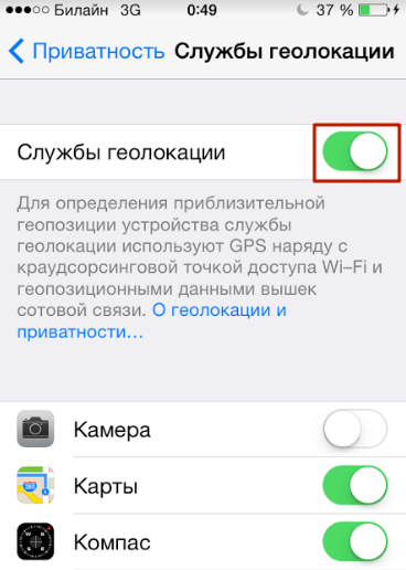
Step 4. Confirm your intention to deactivate geolocation - click " Turn off».

Please note that the iPhone has flexible settings: you can allow some applications to use geolocation, and prohibit others. To do this, you need to adjust the sliders located in the block below.

For example, with the configuration as in the figure, you will be able to use navigation, but geotags will not be attached to your photos.
With flexible settings, the main toggle switch " Location services" must be enabled.
Do I need to disable geolocation of system services?
Subsection " System Services" is located at the very bottom of the block with a list of applications that require geolocation.

A user who visits this subsection will see the following:

Before deciding whether to disable geolocation for system services, you should figure out what functions at least some of them are designed to perform.
The system services listed are common to most iOS versions. There is no need to describe all services - and it is clear that their main goal is to collect confidential data on consumer preferences and sending information to Apple. People who claim that Americans are spying on Russians through smartphones are not too far from the truth.
If you don't want to Apple company, tracking your movements and purchases, replenished its statistical databases, switch the toggle switches in the “ System Services» to the inactive position. It is recommended that all Yabloko members do this: There is no benefit to the iPhone owner from the services, but the charge is consumed faster because of them.
How to enable geolocation on iPhone?
The algorithm for how to enable geolocation on an iPhone differs only slightly from the disabling method described above only slightly. The user also needs to follow the path " Settings» — « Privacy» — « Services geolocation" In the last section, he will see that there is only one slider (the main one), and there is no list of applications that use geolocation.

You need to activate the toggle switch, then disable geolocation from those applications that do not really need this function.
Are geolocation and GPS the same thing?
Users who believe that geolocation and GPS are synonymous are mistaken. Geolocation- This general concept, related to determining the location of the device; GPS is a trademark of the American satellite system navigation. Most often, geolocation uses GPS technology – hence the misconception about the equivalence of concepts.
However, in order for geolocation to be available, it is not at all necessary to turn on GPS - other ways to calculate positional data are possible:
- Via Bluetooth. The location of the object is determined using special beacons Beacon, which are located in public buildings - airports, hypermarkets. In terms of accuracy, this technology is inferior to GPS, because it provides reliable results only if the object is stationary.
- Based on stations mobile communications . The smartphone knows from which station the GSM signal is sent to it and where this station is located. Therefore, using special application, which contains a database of stations, you can use geolocation without GPS. Reliable results using this method can be achieved in megacities where the network coverage density is high, but in small cities determining geolocation through stations is problematic.
- Based on the Earth's geomagnetic field. Navigation based on the planet’s geomagnetic field is the idea of Saratov scientists. Each point on Earth has a unique set of characteristics, which can be used to determine the location of an object (including an iPhone). The technology is only being tested, but large advances are already being given to it.
Although geolocation and GPS are different concepts, and there are several ways to calculate positional data, at the moment quite accurately The location of an object can only be determined via GPS.
What to do if geolocation doesn't work?
If geolocation does not work, it is unlikely that there is a mechanical failure of any part of the iPhone (for example, the GPS module). Most likely, the problem lies at the software level. What to do if the function refuses to function?
Step 1. Proceed to the section " Location services» and make sure that geolocation is activated for a specific application.
Step 2. Check if the Internet is turned on on your iPhone. The network makes it possible to more accurately position the device. Go to the section " Cellular connection » Settings and make sure the Cellular Data slider is in the active position.

Step 3. If the above steps do not produce results, reset the settings after creating a backup copy (instructions for creating copies can be found). Follow the path " Settings» — « Basic» — « Reset" and select " Erase content and settings».

This reset will erase all data from your iPhone.
You need to check whether geolocation works on a “clean” smartphone, that is, before restoring from backup copy. If the function still does not work, you should contact the service.
More often than others, owners of a jailbroken iPhone encounter problems with geolocation. Such users are recommended to install from the store Cydia tweak called libLocation: It is completely free and helps in better positioning of the jailbroken gadget.
Conclusion
If you don't know what it is geotags for photos, and consider navigation on an iPhone unnecessary, most likely you don’t need the geolocation function at all. It is recommended to turn it off - thanks to this measure, you can ensure that your gadget “lives” offline longer. Don't forget about deactivation system services, which do not bring any benefit to the owner of the gadget, but drain the battery faster.