Navigation technologies in agriculture. Coordinate farming. Tutorial. Parallel and automatic driving systems
About the advantages of parallel driving
Let's take a closer look at how, where and how effectively to use systems parallel driving . the main task extremely simple to use - make it possible for a tractor with a mounted unit to pass across the field so that each subsequent strip is exactly along the edge of the previous one, avoiding gaps and overlaps. By moving smoothly across the field, you save significant money.
Any tractor driver, even the most experienced one, will not be able to work without mistakes. And every machine operator’s mistake is either uncultivated land or twice-processed land. In the first case, weeds will grow and crush neighboring rows, reducing the quality of the crop. In the second: this is an unjustified overconsumption of seed material and fertilizers.
In reality, the field processing picture looks like this:
How to ensure an even path of movement across the field for your tractor?- trust the machine operator and his keen eye;
- hire a signalman and send him to run around the field and put up markers to guide the operator;
- use foam markers;
- use parallel driving systems based on receiving coordinates satellite systems GLONASS/GPS.
1. Machine operator skill.
Every farm has excellent tractor drivers. Reliable, don't drink, true professionals. Firstly, such people are the exception rather than the rule. Secondly, no one has canceled the notorious “human factor”. Problems at home, bad mood, didn’t see, didn’t notice, got distracted. No one canceled the weather conditions, no one canceled work only during daylight hours.
2. Hiring signalmen.
Of course, signalmen will make the machine operator’s work easier, because he will have a direction to move. At the same time, signalmen need to be found and paid, in addition to this, the problem of working in poor visibility conditions is not solved, plus, again, there is a high probability of a tractor driver’s error associated with the same “human factor”.
3.Use of foam markers.
Quite high accuracy, the likelihood of error is significantly reduced. The main disadvantage is the instability of markers to such natural phenomena as wind and rain. Many farmers also note the fact that in hot weather the foam material very quickly loses its qualities and the marker becomes almost invisible. The issue of working in poor visibility conditions remains unresolved. Also, do not forget about the high cost of foam markers.
4.Use of parallel driving systems.
Using navigation in agriculture you won't surprise anyone. Almost every farmer has parallel driving systems in his arsenal and will never go back to the previous three methods. Why?
- ability to work in poor visibility (at night, in fog, dust);
- allows you to completely abandon signalers and the use of markers;
- reduces the consumption of seed material, fuel and mineral fertilizers;
- work completion time is reduced;
- fatigue is reduced and the operator’s work efficiency is increased;
- the ability to calculate areas.
All this will allow:
- reduce overlaps by up to 10%, therefore avoiding excessive consumption of seed material, fuels and lubricants and mineral fertilizers.
- increase shift productivity by 20%
- increase working hours by 100% by working at night
How the parallel driving system works
The parallel driving system is based on receiving signals from GPS/GLONASS satellites. The main areas of application are: soil cultivation, sowing of grain and row crops, inter-row cultivation, spraying and spreading fertilizers for precise orientation of the machine during the working stroke.

How it works:
- It is installed on the tractor (all you need is a cigarette lighter) and the antenna is connected. For stable operation it must be brought to the roof;
- The navigator receives data from satellites, as well as differentiated corrections from base stations;
- The machine operator, being at the edge of the field, marks point A, passes the rut, marks point B. The direction indicator lays parallel lines according to the given trajectory;
- In the event of a machine operator error (overlap), the diode scale of the navigator shifts towards the error, and the overlap is hatched on the screen;
- After completing the work, the agronomist can see the quality of the work by uploading the data to the computer.
Field processing modes:
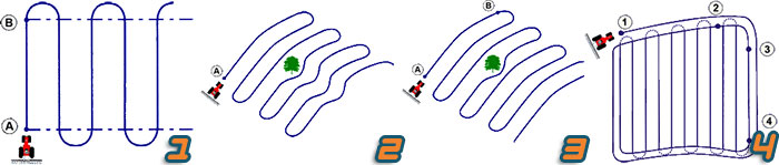
- 1 - “Standard mode” movement occurs parallel to the base straight line AB;
- 2 - “Adaptive curve”: each subsequent run repeats the previous one;
- 3 - “Identical curve” - all subsequent runs repeat the initial curve AB;
- 4 - Preliminary processing of turning zones along the contour of the field (this is line 1-2, see figure), followed by processing the field with paddocks parallel to the base line (this is line 3-4, see figure).
In agriculture, three classes of devices for controlling the movement of tractors and combines using GPS receivers have become widespread and have proven their effectiveness: parallel driving systems and thrusters for autopilot.
Use of space navigation systems becomes possible after installing a special receiver on the vehicle, which constantly receives signals about the location of navigation satellites and distances to them. Depending on the required accuracy, such equipment is controlled by the operator manually according to the indications of the mark on the display screen, or using a thruster or autopilot.
The parallel driving system is the most visual and fastest-paying part of precision farming technology; it is designed for field work and is most effective when used with wide-cut equipment.
Parallel driving system- this is the active participation of the operator in controlling the machine according to the scheme “measuring the current coordinates of the agricultural machine - displaying deviations from the given route on the display in the cabin - rotation of the steering wheel by the operator to keep the unit on the given route.”
Unfortunately, the psychomotor reaction of the average person does not allow parallel driving with deviations of less than ±30 cm, which also corresponds to the accuracy of a GPS receiver that relies only on the usual 24 satellites. In general, the most simple system Parallel driving consists of a GPS receiver with an external antenna and a heading indicator. The systems are easily and quickly installed on a tractor or combine. All you need to do is connect to the power supply and install an external unit ( GPS receiver). Training machine operators to work with this type of equipment, depending on the desired “depth” of study, ranges from several minutes to a day.
It should be noted that the use of parallel driving devices with a unit guidance accuracy of ±30 cm is very limited and is used mainly only for applying fertilizers. To carry out soil cultivation, sowing, plant protection, harvesting and a number of other operations, higher precision of the unit is required. Equipment for more precise parallel driving systems includes:
Navigation receiver with positioning accuracy up to 10 cm, capable of operating at two frequencies;
- display or LED panel;
Controller for calculating deviations on irregularities in the receiver antenna and adjusting the direction of movement;
Thruster device.
There are several common ways to adjust satellite navigation signals to achieve high accuracy. Corrections can be obtained both from geostationary satellites, which will increase the accuracy to ±10 cm, and from the RTK satellite base station, located in close proximity to the field.
Principle and systems of automatic driving (autopilot).
Autopiloting differs from parallel driving in that deviations from a given trajectory generated by the GPS receiver and navigation controller are introduced directly into the hydraulic control system of the tractor chassis through special devices (control valve), eliminating inertia and steering play. In addition, a special wheel angle sensor is installed on the tractor. This system ensures maximum accuracy (deviation ± 2 cm) of movement along the route without operator intervention.
The main advantage of using parallel driving systems is the reduction of errors (minimizing human factor) when processing fields. Practice shows that when spraying crops in the traditional way, most operators prefer to pass adjacent rows with overlap to avoid gaps. As a result, the mutual overlap of the rows, even with the use of foam markers, is at least 5%. The use of course indicators with thrusters reduces the overlap to 2...3% or less.
Receiver supports various options for GPS corrections, including WAAD, OmniSTAR. The use of these corrections makes it possible to ensure accuracy of passes up to ±10 cm.
Panel V graphically shows the current position of the vehicle and provides the driver with additional information when making U-turns or driving in curved lanes. It has a graphic display with the ability to read data in bright sunlight.
Field computer with software - a field data management system used for navigation, automatic driving, recording, field surveying, area surveying, applications with variable indicators.
Controller, using data from the GPS receiver and internal sensors, which are at rest and operating on 6 axes, transmits commands to the control system.
Wheel Angle Sensor designed for continuous feedback with tractor control system.
Hydraulic valve receives electrical signals from the controller and converts them into hydraulic ones, which the system uses to keep the vehicle on a given course.
Thruster provides parallel driving with an accuracy of 10 cm.
Base station transmits GPS position corrections to the tractor's GPS receiver via radio or GSM modem to determine coordinates with high accuracy (error less than ±2 cm).
Possible options for arranging equipment on the tractor for parallel driving and autopiloting.
The minimum set for parallel driving with an accuracy of ±30 cm includes the main components: LED panel, antenna, antenna mounting pad, mounting stand, set of connecting cables, software and instructions for use.
This equipment is in demand due to the fact that it provides cost savings. For example, in Europe, the economic effect of using GPS equipment in agriculture reaches 50...60 euros per hectare.
By the way, the usual satellite navigation, widely used in road transport, can give a maximum accuracy of only about 2 m, which is unacceptable for precision farming technologies. In relation to navigation systems, there are concepts of absolute and relative accuracy. Absolute accuracy is the actual coordinates used to determine the location of an object, for example, a building, car, tractor or combine. For precision farming systems, we can limit ourselves to relative accuracy, i.e., the current location of an object, for example, relative to the first pass, on this moment time. Depending on the equipment used, the relative accuracy should reach values of the order of 2.5...30 cm.
There are currently several correction services operating around the world, but Russian Federation Only one works - Omnistar HP/XP. The service works as follows: Omnistar has own network base stations located around the world. They're in automatic mode calculate the necessary signal correction, and then transmit the correction to a specific GPS receiver via geostationary satellites.
In addition to differential corrections, the RTK mode is widely used, in which a farm’s own stationary or portable base station, and corrections are sent to receivers by a radio signal with a frequency of 450 or 900 MHz. In this case, there is no need to buy a subscription for each receiver; a fairly high relative positioning accuracy is achieved, but, on the other hand, significant one-time costs are required for the purchase and installation of equipment. In addition, there is a limitation on the coverage area due to the characteristics of the signal. So, for a stationary base station this limitation is a circle with a radius of 11 km, in the center of which the base station is located, for a portable one - a little less. Abroad, several farms are combining their RTKs to reduce overall costs and more completely cover fields, while the signal can also be resold.
Since driving accuracy directly depends on the measurement accuracy of the GPS receiver, it is very important for machine operators to know the basic principles of receiver operation. The accuracy of location determination is influenced by several main factors: time discrepancies, the number of simultaneously observed satellites, atmospheric interference, variations in satellite orbits, multipath signal propagation, etc.
Parallel driving and autopilot systems help to accurately maintain distances between machine aisles when performing field work. When using them, technological operations are performed with minimal overlap, saving working and machine time, fuel and lubricants, seeds, fertilizers and plant protection products. Navigation is very convenient for spraying, which is best done at night when the air temperature is lower and there is no wind. Thus, the advantages of parallel driving systems are:
Accuracy of movement of units along row spacing;
Reducing the load on the tractor driver (driver);
Ability to work in the dark and in poor visibility conditions.
For this purpose, parallel driving systems have a special interface that greatly facilitates the work.
Movement can be carried out both along rectilinear and curved trajectories, however, the accuracy of guidance, especially when working with trailed units, is higher when moving along straight lines.
V. I. Balabanov, A. I. Belenkov, E. V. Berezovsky, V. V. Egorov, S. V. Zhelezova
Benefit: " Navigation technologies in agriculture."
Fields of Trans-Urals No. 7 (129) AUGUST 2015
Precision farming and parallel driving systems necessary to optimize the operation of agricultural machinery. These navigation systems can save fuel and reduce the time required to complete specific tasks. As a result of such optimization of activities, it becomes possible to increase the overall load of equipment while maintaining the quality of work. The economic indicators of using parallel driving systems will exceed all your expectations!
About parallel driving systems
Parallel driving systems are becoming indispensable today. Our company offers to buy parallel driving systems at competitive prices.
Buying expensive agricultural equipment that will subsequently be used ineffectively is a questionable decision. Recently, this opinion has been shared by a huge number of agricultural producers, most of whom have already had the opportunity to try out modern navigation equipment in their work.
Working with GPS navigation equipment in the field of agriculture and agricultural production is easy, efficient and convenient. Parallel driving systems provide opportunities for significant savings in fuel, lubricants and consumables, as well as effectively optimizing the movement of agricultural equipment across and between fields. As a result, prerequisites arise for loading equipment two to three times or more. Nowadays, the users of modern navigation equipment and parallel driving systems are people who accurately know how to count their money.
Qualified warranty and service maintenance for a period of up to two years. During this entire period, full consultations are provided and, if necessary, professional configuration of the equipment is carried out.
Our company offers its clients a flexible pricing policy, an individual approach and big choice payment options, along with guaranteed timely delivery and short deadlines for completion of work. You can obtain additional information from company representatives.
You can buy and install parallel driving systems from the Glomos company.
Parallel driving system in agriculture - this is the first step towards the implementation of precision farming, a basic element of resource-saving technology in agriculture.
This system is designed to optimally manage every square meter of the field. Such management can provide a number of benefits, including:
- maximum profit by optimizing production;
- saving natural and economic resources;
- improving product quality;
- environmental conservation.
The practice of introducing wide-cutting equipment and increasing the efficiency of night work convinces of the need to use navigation in managing agricultural machinery. Controlling equipment using a satellite agronavigator makes the operator’s work easier. The tractor driver was able to drive the car not according to external landmarks, but according to instrument readings. As a result, this helps to improve the quality and speed of work. At the same time, the feeling of comfort increases, and he gets tired less.
When implementing a parallel driving system for agriculture, the accuracy of equipment movement is increased even in poor visibility. They are based on preserving not only the end and starting points of the row, but also any reference lines, which allows for the implementation of a wide variety of soil treatment options.
Benefits of implementing the system
Installing the system on a tractor will achieve a number of advantages, in particular:
- Consumables savings. Parallel driving reduces overlaps and eliminates missing uncultivated areas of land. Thanks to this, savings in seeds, fertilizers, and fuel are achieved;
- Improving the quality of field processing. Without this system, the accuracy of passes is significantly lower. On untreated areas, crops grow worse, so yields decrease;
- Increasing work intensity. The use of GPS navigation allows you to cultivate the land in a timely manner and carry out sowing work in a short time. Delay is fraught with losses of the future harvest.
- The parallel driving system can be installed on agricultural tractors Belarus MTZ (82, 3022, 1025, 922.3, 2022.3, 1523, 1221.2, 1021, 952, 920, 892, 320, 82.1), New Holland TD5, T9, T8, T7060, CASE , CLAAS, DONGFENG, Fendt, Foton, ISEKI, JCB, Jinma, JOHN DEERE, Kubota, Massey-Ferguson, Mitsubishi, New Holland, SHIFENG, Valtra, VERSATILE, Xingtai, YANMAR, AGROMASH, VTZ, DT-75 and others or on combines.
If you decide to buy a Leica parallel steering system at the most favorable price on the market, we will help you make the right choice and select an exclusive commercial offer. The cost of this system is affordable for most farmers - whether you are in Moscow or Russia. Thanks to our company's customer-oriented policy, we ensure the success of our partners!
Purchasing GPS navigation equipment from an official Leica dealer is a guarantee of receiving a quality product and decent service.
1,075 usd / pcs.
The GeoTrack Light parallel driving system is a modern budget version of the heading indicator with the function of measuring field area. First-class system accuracy using free GPS satellite signal. An indispensable thing for modern farming: saving fuel, time and money, saving on fertilizers and seed materials. Monitoring the implementation of work performed. All the necessary information is displayed on a large, bright 7-inch (17.8 cm) color screen. The system is equipped with a highly sensitive external GPS antenna to enhance the satellite signal and provide stable accuracy throughout operation. Accuracy of 30 cm is guaranteed the latest technologies filtering and signal processing. GeoTrack Light can be used on high-speed agricultural machinery. ht...
from 65,000 RUR / set
The Campusagro company offers the Campus agronavigator. 8 inch device with 2x nuclear processor and a modern high-precision GPS module. The accuracy of the system is 20-40 cm. The kit includes: Agronavigator; Remote patch antenna; Memory card; Navigator mount;
Charger
; Instructions for use. Agricultural navigator capabilities: Course indicator with two modes: parallel driving (A-B) and free mode; Measuring the field area along the perimeter (contour);
Calculation of the processed area;
GPS assistant for agriculture. A simple tool for sowing, plant protection, fertilizing and spraying. Accuracy: Provides high precision parallel driving (up to 30 cm). Reliability: Rugged and protected display, vibration-resistant mounts and antenna. Convenience: The kit includes all the necessary fasteners for quick installation of the system. The antenna is attached using a durable magnetic mount. An intuitive menu will allow you to quickly get started. Simplicity: Clear menu, convenient settings. Set the grip width and press start - quick installation or reinstallation on the equipment. From this moment GeoTrack Explorer is ready for use. Benefit: Improved quality of work and additional benefits. Savings: Forget about using foam...
from RUB 50,000 / pcs.
Agro navigator MojoMINI 2, Swiss company Leica from the official supplier with warranty and technical support. accompaniment. Accuracy 12 cm. Leica MojoMini 2 is a convenient, reliable and inexpensive parallel guidance navigator for precision farming. You receive inexpensive equipment that allows you to increase the productivity of your equipment and reduce cost overruns due to inaccuracy in the work of your workers. There is no need to use markers, and in the dark and in poor visibility they are simply irreplaceable. The convenient 11cm touch screen is easily controlled by the touch of a finger. The modern Leica SmartAg DGPS antenna is the best in its class, providing row accuracy of +/- 12 cm. Leica mojoMINI works correctly in GPS systems and GLONASS (R...